*Grand Central's advertising states the landfill is forecast to close in 2030. After that, there will be no heat to recover from burning landfill gas - Synagro will burn 100% natural gas after closure of the landfill.
Proposed Synagro plant above basin (dashed blue line), landfill below
One of the regulations for sedimentation basins is that the bottom of the basin be above the level of neighboring wetlands, and perennial streams. This rule was enacted after Sedimentation Basin #2 was approved. Now it is proposed to modify the basin, and it is quite possible the new rule applies. In DEP's deficiency letter, this is one of the deficiencies noted..
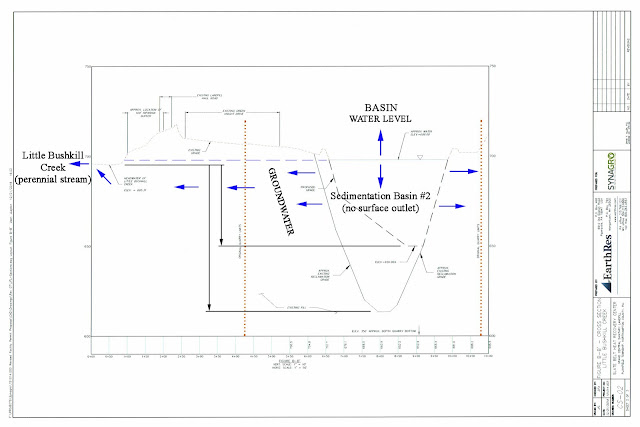
Let's look at a profile of Sedimentation Basin #2. The diagram was submitted by Synagro, and is marked up to emphasize the location of Little Bushkill Creek, and the fact that the water level in the basin goes up and down as it exchanges water with the surrounding water table. There is no other outlet.
It is obvious from the diagram that the bottom of the current sedimentation basin is about 75 feet below the creek headwaters, and the proposed basin bottom (black dashed line) after partially filling (which will require a permit now that a waiver is no longer guaranteed) is about 30 feet below the creek headwaters.
It will be interesting to see how this plays out. On paper, it looks like a problem to a casual observer since the bottom of the basin is below the creek, and it should be above.
Of note in this diagram is the word "APPROX" used liberally. Synagro has no idea exactly what the contour is of the existing basin, since they have refused to do a hydrogeological study. There is no guarantee the existing bottom is at 620 feet - it could be far deeper since the quarry depth was several hundred feet at one time. Under the surface of the water in the basin, no one really knows what is happening - including DEP.
Current and proposed bottom of sedimentation basin is below Little Bushkill Creek tributary elevation
Sec 7.1 of DEP Erosion and Sediment Control BMP's manual


