
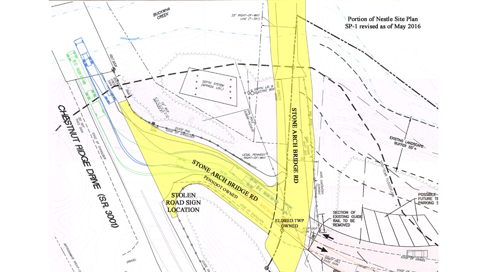
In its application, Nestle refers to the short road that connects Chestnut Ridge Drive to near the Gower Estates LLC property as an "unnamed township road" numerous times. This is not correct either - the name of that road is "Stone Arch Bridge Road". There was a road sign at Chestnut Ridge Drive until it went missing in the last few years. Wonder who took it.
But it gets worse. Much worse. Hanover Engineering indicated in its reviews that the right of way (ROW) of road T-361 (Stone Arch Bridge Road) must be shown on the Site Plan. Look where Nestle's engineer placed it (red rectangle):

Nestle depicts Stone Arch Bridge right of way hanging halfway over Buckwha Creek and dead-ending in a field instead of spanning the road - field of dreams?
"Stone Arch Bridge Rd" labels, "stolen road sign" and ROW highlighting added by author
"Stone Arch Bridge Rd" labels, "stolen road sign" and ROW highlighting added by author
The lime green rectangle is an approximation of where the ROW actually is - you know, like actually encompassing the road? On the southern portion of Stone Arch Bridge Road where it turns west towards Chestnut Ridge Drive, Nestle's purported ROW is entirely to the west of the road edges depicted. Who builds a road next to its right of way instead of within it? In addition, the depicted ROW abruptly ends without explanation in the middle of a grassy area which is a portion of the Old Mill property. Nestle appears to not want to show that the full 33' width of the Stone Arch Bridge Road right of way separates the Gower Estates LLC property from PENNDOT property.

Nestle's site plans submitted in December 2015 didn't mention road or right of way - fail
A deficiency independent of the right of way misrepresentation is that about 30' of Stone Arch Bridge Road just north of the Gower entrance is depicted as entirely within the Gower Estates LLC property boundary. Looks pretty fishy, ey? More to follow on this subject later.

An approximate corrected depiction of the Stone Arch Bridge Road right of way
What's with that funky lot line - where is Surveyor Beers when you need him?
No comments:
Post a Comment