Wednesday, June 8, 2016

The reason Nestle withdrew its application for a water extraction permit in Kunkletown, Eldred Township

On June 8, 2016, Nestle Waters announced it was withdrawing its application for a special exception permit.  After investing perhaps $250,000 in this project, why?

Let's recall that there were two hurdles for Nestle to overcome, both obtaining a permit and landowner Gower defending the court appeal of the ordinance change that allowed Nestle to target this site - if the appeal was won, it would have voided the amendment from Day 1.  Nestle needed a favorable outcome of both of these, and they wouldn't have obtained either one...

Special Exception Permit

In only an hour or two of cross examination of Nestle's civil engineer Ed Davis at the May hearing, very significant weaknesses were exposed.  First, it was established that Nestle's 30,000 gallon water silos are really tanks, and storage tanks are not permitted where Nestle wanted to place them.  Counsel Mr. Timothy R. Weston and engineer Ed Davis had tried to consistently call them silos - but slipped occasionally.  Second, Nestle ignored the fact there are two roads across the site (they didn't even show them on their Existing Features site plan), and that they had blocked one of them already with well installation.  They proposed placing a building in a road, and then had the nerve to argue it was a "driveway" with "some stone on it".  People have used this road since the 1960's as the sole access to their properties.  That Nestle thought it would get away with these absurd deceits of residents whose families have called Kunkletown home for a century or more is incomprehensible.  Is there a farmer anywhere that calls a water tank a "silo"?  Look who called a water storage tank what it is, at a Nestle Waters site only 15 miles away:

In Nestle Waters' 2004 Bangor, PA special exception application Mr. Weston called the water tanks "storage tanks".  True story.

None other than Nestle counsel Weston!  Mr. Weston's own words would have been placed into evidence if hearings had proceeded, on cross examination of Mr. Davis - who incidentally was also involved in the Bangor operation.  Above-ground storage tanks are not permitted where Nestle planned them on the Gower property.   Mr. Weston and Mr. Davis have been through this rodeo many times.  A two-person hit squad.  Busted.


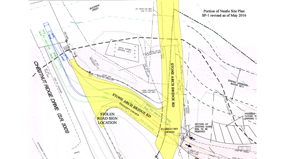
If on-site roads had been shown , it would be clear an ordinance violation has already occurred
Note: Sandy Hill Path's edges (brown lines) were not shown on Nestle's Site Plan

Nestle's own exhibit NWNA-28 shows that Sandy Hill Path is a "road" - you can't make this sh!t up

Looking down Sandy Hill Path at blockage at Nestle well PB-2
Why the hell would they block the road, and not find a better place?

There is plenty more, but there is no need to go further.  Nestle needed variances for both of these ordinance violations, and former (as of June 11) Eldred zoning officer Helm didn't catch that.  If he had, Nestle would have been required to apply for variances that they could not obtain.  They couldn't obtain them because they couldn't meet the criteria.  One criterion for relief is that the site can't be used for another use.  There are two other uses already on the site - end of story, done, finished.  Thus, Nestle's application was total garbage from inception - a pile of crap.  If not for the incompetence of Helm, a lot of attorney's fees could have been avoided.  Just because Bub didn't catch it doesn't mean Nestle gets to violate the ordinance.  Bub couldn't catch a snowflake with his hat in a blizzard.
Nestle Engineer Ed Davis would have had a bad night if the June 15 hearing had taken place

If the June 15 hearing had taken place, Ed Davis' testimony would have been hacked to pieces on further cross examination.  Lot lines depicted wrong on the site plan, a right of way shown where it isn't, many other deficiencies.  It would have been ugly.  We can take much satisfaction Nestle is gone, but dang it would have been fun to pummel them into the ground on their way out of town.

Update 6/9 2:15PM See a previously unreported major deficiency in Nestle's Site Plan here.

Court appeal of amendment that allowed Nestle to apply for a permit

What has become obvious to anyone with eyes, and who has been exposed to the process that was required but was not followed, is that the procedural challenge of the amendment under the laws of Pennsylvania would have been easily won.  The recent discovery that the advertisement of the amendment was modified after it was sent to the Pocono Record for advertisement was just the icing on the cake; procedures were violated every single step of the way.  The probability the appeal would have been won at the county court was very high - 80% or more in this author's opinion.  If When won, it would have voided the amendment from the day it was enacted, meaning Nestle could not proceed.

Depositions were about to take place, and several people had reason to fear this.  Who knew about and took part in efforts to alter the ordinance?  What about Darcy Gannon altering official planning commission minutes on request of her daughter's boyfriend's attorney?  Who altered the Public Notice ad that was placed by the landowner's attorney's law firm after it was submitted, and was that it done in writing or by phone call to a "friend"?  Why didn't the CJER solicitor or county planning commission review the water extraction amendment?  In Nestle's application withdrawal statement on June 8, they said that the landowner had "concerns" about the project proceeding. Um, yeah, and lots of others too.

Conclusion
About four months ago, I looked Mr. Andreus in the eye and said "This isn't going to end well for you."  I am not clairvoyant.  The writing was all over the wall.  It's pathetic that Nestle put Eldred Township though this.  The greed is palpable.

Nestle pulls out of Kunkletown/Eldred Township - don't let the doors of the Community Center hit you in the ass

Nestle water scavenger Eric Andreus announced at this evening's Eldred Township Board of Supervisors meeting that Nestle is pulling the plug on the absurdly envisioned and poorly planned operation to suck the very life blood out of Kunkletown and destroy its character and ambiance.  As reported here and in the press, their application was grossly deficient.  This announcement by Nestle was an acknowledgement that they could never obtain a permit, and even if they did they would have lost the court appeal of the ordinance change.


Nestle Waters statement with commentary added by this blog's author

Congratulations to the community for coming together in solidarity to fight the corrupt and incompetent actions that allowed Nestle to even apply to locate an operation in the village.

The hard and diligent work of the new Eldred Township Supervisors, the Eldred Township Planning Commission and its new solicitor, Hanover Engineering, concerned citizens and a few non-citizens made this victory possible.  Screw Nestle Waters and the horses they rode in on, and the assholes who clandestinely invited them into town through many acts intended to deceive taxpaying citizens and deprive them of their right to due process.  The citizens are not your whores.  Incompetent fools from the so-called Planning Consultant, CJER, the county planning commission and to top it off devious and unethical attorneys and proudly corrupt politicians.

Monroe County is a damned cesspool in places when it comes to government.  Eldred Township has put a marker down that it is bucking that trend.

Housekeeping announced at BOS meeting

In other news, Ellerslie "Bub" "Nestle's application looks just fine and you can burn egg cartons" Helm was told he need not come to work after this Friday.  Eldred Township will be contracting out zoning and building code official tasks from this point forward.  Also, recently appointed Solicitor "Bulldog" "Is naming a road across someone's property really a problem?" Karasek was replaced by the supervisors with Mr. Gaul this evening.  Mr. Gaul is also the planning commission solicitor, and a heck of a nice guy.  Keep up the great work, Eldred Supervisors!

Edit 6/9 10:30am: Eldred supervisors switched their legal advertisements from the Pocono Record to the Times News at last evening's meeting.  This in the wake of the revelation on this blog that the 2014 water extraction amendment text authorized to be advertised by the Record had language removed prior to printing.  Who made that call?  It wasn't Hillary Clinton.  And who took it?  Kelli?  Congratulations to the supervisors for shoving it up the Record's derriere.  More to follow on this blogger's investigation into this altered advertisement matter.


Who would have thought the residents of
Eldred Township and Kunkletown could destroy such wickedness?

Water destroyed this bitch too

Sunday, June 5, 2016

Nestle Site Plan road right of way details FUBAR at entrance to target site

Nestle has a made a big deal out of their claim that the proposed site has direct access from a PENNDOT road.  But it doesn't, as was shown here.

In its application, Nestle refers to the short road that connects Chestnut Ridge Drive to near the Gower Estates LLC property as an "unnamed township road" numerous times.  This is not correct either - the name of that road is "Stone Arch Bridge Road".  There was a road sign at Chestnut Ridge Drive until it went missing in the last few years.  Wonder who took it.

But it gets worse.  Much worse.  Hanover Engineering indicated in its reviews that the right of way (ROW) of road T-361 (Stone Arch Bridge Road) must be shown on the Site Plan.  Look where Nestle's engineer placed it (red rectangle):


Nestle depicts Stone Arch Bridge right of way hanging halfway over Buckwha Creek and dead-ending in a field instead of spanning the road - field of dreams?
"Stone Arch Bridge Rd" labels, "stolen road sign" and ROW highlighting added by author

The lime green rectangle is an approximation of where the ROW actually is - you know, like actually encompassing the road?  On the southern portion of Stone Arch Bridge Road where it turns west towards Chestnut Ridge Drive, Nestle's purported ROW is entirely to the west of the road edges depicted.  Who builds a road next to its right of way instead of within it?  In addition, the depicted ROW abruptly ends without explanation in the middle of a grassy area which is a portion of the Old Mill property.  Nestle appears to not want to show that the full 33' width of the Stone Arch Bridge Road right of way separates the Gower Estates LLC property from PENNDOT property.

Nestle's site plans submitted in December 2015 didn't mention road or right of way - fail

A deficiency independent of the right of way misrepresentation is that about 30' of Stone Arch Bridge Road just north of the Gower entrance is depicted as entirely within the Gower Estates LLC property boundary.  Looks pretty fishy, ey?  More to follow on this subject later.

An approximate corrected depiction of the Stone Arch Bridge Road right of way
What's with that funky lot line - where is Surveyor Beers when you need him?

Wednesday, June 1, 2016

Nestlé expert witness misinterprets second exhibit in a row

Yesterday, covered here was how badly Nestle expert witness civil engineer Ed Davis misrepresented that there is PENNDOT road access directly to/from the Gower Estates LLC property.  This simply is not true based on the evidence in Nestle's own exhibits.  On cross examination, he could not explain to Attorney Mark Freed how Nestle exhibit NWNA-28 shows that it is true, which he had opined on direct testimony.

Just prior to Nestle's introduction of NWNA-28, Nestle introduced another exhibit related to the same misrepresentation - that there is PENNDOT access directly to the property, which Mr. Davis also did not represent or interpret correctly.  This is exhibit NWNA-27, which is a deed for the Old Mill part of the Old Mill property, subsequent to most of the property already having been subdivided off.


Here is the dialog between Nestle Counsel Weston and Mr. Davis about NWNA-27:
Mr.Weston: "Please identify it" [exhibit]
Mr. Davis: "NWNA 27 is a Sheriff's Deed"
Mr. Weston: "And what does this deed explain or stand for?"
Mr. Davis: "It shows...this was done back when the Chestnut Ridge Drive was relocated and it depicts the conveyance of property to Metropolitan Mortgage Securities from the State of Pennsylvania.  And it excepts out property in the vicinity of the northwest corner of the property off Chestnut Ridge Drive where the driveway is located."
Mr. Davis' testimony contains a few errors.
  1. This deed is not from when Chestnut Ridge Drive was relocated - look at the date - it is from 29 years later in 2002.  This deed is from when someone defaulted on his mortgage.
  2. The conveyance is not from the State of Pennsylvania - the state doesn't lose property.  The conveyance is from Steven Segal via the Sheriff to the mortgage company.
The conveyance "excepts out" the land that PENNDOT took in 1974, 0.71 acres.  But this is not adjacent to the Gower property.  This is the land that PENNDOT took that is detailed in exhibit NWNA-28, and thus this exhibit does not support an argument there is a direct PENNDOT access - in fact it helps shine light on the fact that there is not.

Tuesday, May 31, 2016

Nestlé expert witness misrepresents that access to target property is directly from PENNDOT road

At the March 20, 2016 zoning hearing board hearing, Nestle witness Ed Davis was questioned by Nestle counsel Timothy Weston about access to the Gower Estates LLC property from Chestnut Ridge Drive.  In multiple instances, Mr. Davis stated or agreed that the property has direct access onto land owned by PENNDOT.  During this hearing, several updated site plans were put into evidence, with notations that there is a PENNDOT right of way (ROW) on the property line at the entrance road to the Gower property, and Mr. Davis testified that access to the Gower property is directly from a PENNDOT road.  This is not true.


Nestle's site plan SP-1 falsely shows (red) that the Stone Arch Bridge Road right of way runs adjacent to the Gower property line far from where the road is - the ROW actually lies (lime green) within Gower's property boundary as reflected in the deed, but not as much as the site plan depicts
(red and lime green figures and road name added by the author)

The depiction of the right of way for Stone Arch Bridge Road on Nestle's site plans (which Nestle didn't bother to label by name) is absurd.  They show it askew from the road by about 5 degrees.

In preparation for the testimony, Mr. Weston placed into evidence exhibit NWNA-28 (below, marked up), a PENNDOT diagram that depicts land taking and land abandonment associated with the relocation in the 1970's of the road now known as Chestnut Ridge Drive.  This diagram shows that the old stone arch bridge and the portions of road that led to it on each end were abandoned, and lands belonging to Joseph and Rose Capone were taken in order to construct the new bridge and realign the road.  There were other lands taken between this area and Kunkletown Road (referred to as "adverse" in the diagram) not detailed on this particular sheet. The land taken from Capone has been outlined in red by this author.  The area of interest is the land to be abandoned, which has been outlined in aqua.  Zoom in to see the detail in the inset.


The inset, which is simply an enlargement (no fancy graphics processing needed) of the area of interest, confirms that upwards to the right diagonal lines are within the area that is outlined in aqua, and downward to the right lines are within the area that is outlined in red, and the two do not overlap.  The diagram key in the lower right corner informs the reader that the former is land to be abandoned, and the latter is land to be taken.
This enlargement shows that the line shading indicating PENNDOT taking ends at the old road

During the March hearing on direct testimony, Mr. Davis testified that there was cross-hatching that distinguished taking from abandonment, but he was not questioned in detail as to the boundary of the area to be taken and the area to be abandoned.  He simply testified that the diagram depicts land exchanges that resulted in PENNDOT having an access road that connects directly to the Gower Estates LLC property.  Mr. Weston emphasized the point, and Mr. Davis agreed.  The problem is, the diagram clearly shows otherwise.

March 20, 2016 beginning of direct testimony on topic:
Mr. Weston: Did you... um... research the background of the Pennsylvania Department of Transportation's relocation of Chestnut Ridge Drive"
Mr. Davis: "Yes, we did."
 March 20, 2016 conclusion of direct testimony on topic:
Mr. Weston: "So the area of the road from the place where the Gower Estates private driveway... or stone...  shown as stone road on this document leaves the property is on the PENNDOT right of way?  Directly?"
Mr. Davis: "Yes.  Yes.  PENNDOT has property adjoining the Gower Estates property where the driveway is located."
The entire segment can be seen below.
As an aside note that Mr. Weston is trying to claim that the named road Sandy Hill Path across Gower's property is a  "driveway".  Not according to any internet map source, or this diagram.  Nestle in its response to Hanover Engineering stating private roads must be shown made this same claim.  Too bad someone decided to have Sandy Hill Path named - lol.

On May 18, 2016, on cross examination, Mr. Davis was questioned about NWNA-28, and asked to distinguish between lands to be taken and lands to be abandoned.  He said that he could not, and at one point suggested the diagram shows that the two overlap.  Eldred attorney Mark Freed asked Mr. Davis if that could be possible, and Mr. Davis agreed that was not possible.

There are multiple problems here.  First is that expert witness Ed Davis sounded authoritative on March 20 when asked about this diagram, and he was conclusive as to what it depicts.  Now he can't say for sure what it depicts in terms of lands to be abandoned and taken.  More important is that Mr. Davis, who is a professional engineer, evidently did not take the time to examine this map carefully before drawing the conclusions that he testified to.  For God's sake, as an engineer, if you can't make out a detail don't you take reasonable steps (eg photocopy enlargement) to figure out what it is?  He even drafted a response to Hanover Engineering comments based on his interpretation of this diagram.  But when he is questioned adversely, suddenly he has no idea what the details are that justify a key representation that he made on multiple occasions?

Mr. Davis should be handed a $1 magnifying glass at the next hearing when cross examination continues.  You just can not make this *#)t up.

See Mr. Davis being definitive about exhibit NWNA-28 on direct testimony about this matter at time stamp 01:38:06.  Those who attended the May 18 hearing saw him wavering like a drunken sailor under Mr. Freed's questioning.


Who owns the land that PENNDOT abandoned?

Glad you asked.  Shows you are paying attention, unlike others.  First, a look at the Gower Estates LLC deed is helpful:
Excerpt of Gower Estates LLC deed recorded June 9, 2004

This states that a portion of the PENNDOT road right of way lies within the Gower Estates boundary.

The answer is none other than "Eldred Township".  Why didn't Mr. Weston enter the document below into evidence at the May 18, 2016 hearing, before Mr. Davis completed his direct testimony?  The official minutes reflect that this document was discussed at the March 17, 2016 Eldred Township Planning Commission meeting.  You can see why Mr. Weston didn't use it - this 1991 document together with the 1973 PENNDOT diagram show that the stone arch bridge and approach roadways are now Eldred Townwship property.  The southern approach, nominally 33' wide, lies between Gower Estates LLC property and PENNDOT-owned land at the Gower entrance.  Therefore there is not a direct access to a PENNDOT ROW from the Gower Estates LLC property.

Helen Mackes is credited with bringing forth attention to this document.  Helen lives in Eldred Township - this author does not, which Helen mentions often.

Overlay of PENNDOT taking/abandonment diagram boundaries on Nestle SP-1


Monday, May 30, 2016

Sharon Solt doesn't know who authorized the 2016 water extraction amendment 1-1/2 months after she seconded the motion to advertise it - true story!

Yet another page from the "you just could not make this *(@! up" book.  Previously, it was reported here that former supervisor Sharon Solt as Eldred Township's Right to Know Officer in June 2015 in response to a request stated that she was unable to determine who authored the 2014 Eldred Township water extraction amendment.  In her own township while she was supervisor and she was secretary and she was on the CJER Planning Committee and its secretary.  Setting aside the fact that it is her duty to find out if such a record exists as RTK officer, come on now, be serious!

Now she doesn't know anything about how or when the 2016 Eldred Township water extraction amendment was authorized, even though she seconded the motion to do it herself.  No, this is not a joke.

At the January 2016 Eldred Township Board of Supervisors meeting, Mary Anne Clausen made a motion to advertise a hearing for an amendment that would overturn the illegally passed 2014 amendment that allowed Nestle Waters Deer Park to apply to extract water from the commercial zoning district.

It should be noted that Ms. Clausen twice made such a motion in 2015, when the landower's girlfriend was supervisor, and neither she nor Ms. Solt would second that motion - this would have avoided the legal battle now being waged at the zoning hearing board and in county court - both of which should result in positive outcomes for concerned citizens, and a lot of unnecessary expense to Eldred Township residents.  This whole episode was avoidable, if the people who were caught red-handed had just done the right thing, instead of believing that they would succeed with the initial plan.

Anyhoo, Ms. Solt, in true form, voted against Ms. Clausen's motion in January, which had been seconded by newly seated supervisor JoAnn Bush.  The motion passed 2-1.  This was Solt's last stand after the puppets failed to be appointed at the reorganization meeting earlier in the evening.

Ms. Solt then seconded a motion to advertise the hearing, and to send the amendment to planning agencies for recommendation, and the motion passed 3-0.  This event was covered by two local newspapers.  Here is the official record:


OK, now for the money shot.  Not two months later, Ms. Solt is puzzled about who voted on such an amendment and sends the following email to her colleagues on the regional planning committee CJERP to ask them:


Who's on first base?  I don't know - third base?  Can you imagine what the people who received this email thought?

First and foremost, why is Ms. Solt asking CJERP members?  This is an Eldred BOS function.  And Ms. Solt is asking this question 2 days after the email was sent that she is replying to.  It didn't occur to her in that time:
  1. that She is the one who seconded the motion on the vote that did exactly what she is asking?
  2. to check the minutes from January and February that she and other supervisors had been distributed?
  3. to ask her two fellow board members?
  4. to ask the person who took the January minutes (Secretary Ann Velopolcek)?
  5. to find another of the 100+ people who attended the January board meeting?
  6. that she should extract her head?
Enjoy your retirement - you were overworked or just maybe you weren't capable of doing the job in the first place.  You don't appear to have an understanding of routine municipal procedures after 10 years in office,   And she suggested to others that they should have paid better attention to what was going on at town meetings?  This may partly explain why minutes often didn't reflect what happened, according to residents present at township meetings.


Sunday, May 29, 2016

Individual changes to amendments advertised on April 14 and April 21 2014 by CJER examined, revealing deception of public

In the first document below is the text of amendments that was submitted by Special CJER Solicitor Fareri to the Pocono Record, to be published in a Publlic Notice on April 14 and April 21, 2014.  The Record confirmed that it still has the submitted file today.  Colored ovals have been added to highlight that items to be added have double underline (tangerine), and items to be removed are shown with strike through (lime green).  There are 23 items with double underline, and 13 with strike through.

In the second document, the advertisement as printed is shown.  The Record substituted single underlining for double, and there is no indication that this was authorized.  The items that were to be double underlined have been circled in yellow, and the items to be removed and displayed with strike through have been circled in lime green.

Note that a key has been added to both documents, something neither the planning consultant or the CJER Special Solicitor saw fit to do to explain to the reader what was changing and how.  The Municipalities Planning Code requires the municipal solicitor, James Fareri of Newman Williams in this case, to advertise amendments and amendments that substantially alter pending amendments.

A very significant discrepancy exists; of all the change notations, the only two that were inexplicably not printed were the underlining of manufacturing, light, and the strike through of industry.   These should appear in the lower document in the area circled in red, but do not.  Yet these two notations were contained in the file received by the Record (top document). The probability this was an error by the Record  is 1/23*1/13 = 1/299 = 0.3%, meaning the probability it was intentional is 99.7%.  Could this be related to why Mr. Fareri has advised CJERP members not to discuss what happened in 2014?

The Monroe County Planning Commission and CJER appear to have been overwhelmed by the excitement of the moment in April 2014, because the evidence suggests that the supplemental amendments added after March 27, 2014 were not reviewed by either one or the CJER solicitor.  CJER was so confident that they cancelled their April 2014 meeting at which they possibly could have identified major problems (improper advertising, amendments not reviewed by CJER townships, amendments never authorized, amendments not reviewed by county planners) prior to the May 1 adoption.  But who was so caught up in their personal euphoric crapulence that they would request the Record make this unauthorized change to what was submitted? Who cared so much about the amendment being passed that they risked changing a Public Notice that nobody reads?